Other Sightseeing Spots in Kumamoto Area
Area
-
-
Kumamoto


-
-
Kumamoto

Category
-
- Shiroyama Observation Deck
-
![rating-image]() 4.053 Reviews
4.053 Reviews - Travel / Tourism
- Kumamoto Pref. Asoshi Ichinomiyamachisanno 2351
- This viewpoint is located 748 meters above sea level. Located at the start of the Yamanami Highway that leads to Beppu, it's a nice spot for a break while driving. It has a magnificent view of Aso Gogaku, the five peaks of Mt. Aso-with the farmland of the Aso Valley stretching below. On autumn early mornings when conditions are right, you might see the phenomenon known as unkai, a sea of clouds.
-
![]()
We were heading back to Fukuoka and this lookout is on the way and we made a quick stop. The view is very beautiful looking back down the flat valley at Aso station and surrounding mountains...

-
- Kabutoiwa Observatory
-
![rating-image]() 4.024 Reviews
4.024 Reviews - Travel / Tourism
- Kumamoto Pref. Asoshi Nishikozono
- This is an observatory deck on the prefectural road Route 339 (Milk Road). Here one can see the five peaks of Mt. Aso and its outer crater rim, and a sea of clouds in the early morning. It’s recommended for a drive break, or to use the shop or 24-hour toilet facilities.
-
![]()
訪問は12月の20日過ぎ、地震によって元々あった展望所が壊れたようで、まだ重機で整地?していた。 杭の内側までは行けるのでギリギリまで行って景色を堪能。 曇り空ではあったが、噴煙もバッチリ!大観峰より噴煙は見やすいかも。

-
- Daikanbo Observation Deck
- Travel / Tourism
- Kumamoto Aso-shi Yamada 2090-8

-
- Yamanami Highway
- Travel / Tourism
- Oita Pref. Kusugunkokonoemachi Tano
- This is a one-hour drive course that connects Yufuin in the north and Kumamoto Prefecture’s Aso-gun Minami Oguni-machi Town in the south, selected as one of Japan’s greatest 100 mountain range roads. There are spots where one can enjoy views of the Kuju Mountain Range, hot springs, and Kogen gourmet food. There are many spots where one can feel close to the mountains such as the Tadewara Wetlands which formed from springs at the base of mountains in the Kyushu volcanic group and Yamanami Farm. Coming from the direction of Fukuoka/Oita, get off the Oita Expressway at “Yufuin IC” and take National Road 210, then enter the Yamanami Highway.

-
- Tawarayama Observatory
- Travel / Tourism
- Kumamoto Pref. Asogunminamiasomura Kain Mt. Wakari
- This is an observatory on the prefectural road Route 28. Take the short mountain road from the roadside car park, and one can see all from Mt. Kuju to Komezuka, the five peaks of Mt. Aso, and other Aso scenery. In addition, the southern outer crater rim promenade facing the summit of Mt. Tawarayama begins from here. It also features convenient shopping and toilet facilities.

-
- Ichifusa Dam Lakeshore
- Travel / Tourism
- Kumamoto Pref. Kumagunmizukamimura Yuyama
- "Ichifusa Dam was built in 1960 in Mizukami Village, Kuma County, Kumamoto Prefecture. Yoshino cherries were planted around the dam lake when the dam was built, and today the lakeshore is a renowned destination for viewing cherry blossoms in spring. The area's ""10 thousand"" cherries sprawl along the shore for 14 kilometers, and visitors can appreciate their beautiful blossoms. A cherry blossom festival is also held here during the season, and a portion of the trees are lit up at night to delight visitors."

-
- Minami Aso Panorama Line Observation Deck
- Travel / Tourism
- Kumamoto Aso-gun Minamiasomura Nakamatsu

-
- Amakusa Pearl Line (Amakusa Itsutsubashi)
- Travel / Tourism
- Kumamoto Kamiamakusa Oyano-Matsushima

-
- Takabutoyama Lookouts
- Travel / Tourism
- Kumamoto Pref. Kamiamakusashi Matsushimamachiamura
- This observation platform is in Kamiamakusa City. The nationally designated scenic spot overlooks Unzen-Amakusa National Park and the islands of Amakusa Matsushima. You can also see the first to the fifth bridges that connect the Amakusa Islands. There are 30 cherry trees on the hilltop around the lookout, so there are lots of visitors in spring when the flowers are in bloom.

-
- Mt. Senganzan Lookout
- Travel / Tourism
- Kumamoto Pref. Kamiamakusashi Matsushimamachiaitsu
- This observatory is in Kamiamakusa City. Designated a National Cultural Property and Place of Scenic Beauty, it has a view of the Amakusa Islands and the five bridges that connect them. You can see the Ariake Sea to the west, the Yastsushiro Sea to the east, and even out to Mt. Aso on clear days. Around the lookout are both wild mountain cherry trees and ones that have been planted. It's a popular spot when they're in bloom.

-
- Marusuzu Bridge
- Travel / Tourism
- Kumamoto Pref. Asogunminamiogunimachi Manganji
- A bridge located in Minamioguni Town, Aso County, Kumamoto Prefecture. Spanning the Kurokawa Onsen hot spring district, during the Yuakari event each year in winter, carved bamboo tubes lit from within and bamboo work lights are placed around the bridge. Many tourists come during the event to enjoy the magical sight of the lights reflecting off the river surface.

-
- Amakusa Matsushima Observation Deck
- Travel / Tourism
- Kumamoto Pref. Kamiamakusashi Matsushimamachiaitsu 5986
- This 20-meter high lookout is near Matsushima Bridge, one of the five bridges connecting the Amakusa Islands. It has a view of the five bridges, seasonal island scenery, and even the Shimabara Peninsula and Mt. Unzen on clear days. It's also a great spot to catch the sunset and has been chosen as one of Japan’s 100 best sunset destinations. Since there's a parking lot, it's easy to stop off while you're driving by.

-
- Tenmon Bridge (Bridge No. 1)
- Travel / Tourism
- Kami Amakusa City, Kumamoto Prefecture, Uki City
- "A bridge located a 30-minute drive from the Matsubase Interchange. Situated along National Route 266, the bridge is the first picturesque viewpoint along the Amakusa Pearl Line, a scenic driving route selection for inclusion in a list of Japan's 100 best roads. Connecting Kyushu and the islands of Amakusa, the bridge serves as the gateway to Amakusa. Its 300 meter span from pier to pier is the longest of the five Amakusa bridges, while its total length is 502 meters. Since it was opened in 1966, the bridge has contributed greatly to the development of many local industries and is also known as the ""bridge of dreams."" The view of the sun rising beyond the bridge, visible and photographable from the Shintenmon Bridge from fall through winter, is particularly stunning."

-
- Tenjyo Bridge
- Travel / Tourism
- Kumamoto Prefecture

-
- Buzen Kaido
- Travel / Tourism
- Kumamoto Yamaga Chuodori 510-2 Yamaga Onsen Tourist Association

-
- Hiranodai Highland Viewing Platform (Lovers Hill)
- Travel / Tourism
- Kumamoto Aso-gun Minamiogunimachi Manganji Hiranodai
- "This observatory is located a 10-minute drive from Kurokawa Onsen. From here visitors can get a sweeping view which stretches from Seiryu-no-mori to the five peaks of Mt. Aso. The observatory's sprawling panoramic view encompasses the Kuju Mountain Range to the east and Mt. Aso to the south, and, if you come here early in the morning and are lucky, you might just get to see the area's famous ""sea of clouds."" The observatory has been designated a Lover's Sanctuary, and it is said that couples who ring the observatory's bell make a vow of everlasting love. The observatory is also little-affected by city lights and the area's skies are clear, and at night it becomes a popular photography spot from which you can see star-filled skies."

-
- Reidaikyo Bridge
- Travel / Tourism
- Kumamoto Shimomashiki-gun Misatomachi Kiyomizu Toyotomi
- This stone bridge spans Funatsu Gorge, the most difficult to cross part of the main course of the Midori River, a body of water which was a key transportation hub in ancient times. 90-meters-long, the huge bridge is one of the largest single arch bridges in Japan. The bridge was built in 1847 primarily by the three brothers Usuke, Uichi, and Johachi in Taneyama Ishiku stonemason group. Designated a National Important Cultural Property, the bridge's appearance is both imposing and graceful. The bridge is lit up at night, enabling visitors to enjoy a magical side of the bridge quite different to how it looks during the daytime.

-
- Top of Mt. Takabuto
- Travel / Tourism
- Kumamoto Kamiamakusa Matsushimamachi Amura
- "This observatory is located on Mt. Takabuto, a mountain selected for inclusion in the Japan Sunset Best 100. From the mountaintop 117 meters above sea level, visitors can get a sweeping view of the fantastic scenery of Amakusa Matsushima, part of Unzen-Amakusa National Park. The mountaintop is also a famous destination for viewing the setting sun and has been included in the Japan Sunset Best 100 list. In ancient times, the mountain's name was written with characters meaning ""high fat mountain,"" but after a local military commander had fun dancing on top of it during the Warring States period, it came to be written with characters pronounced similarly but meaning ""high dancing climbing mountain."" Some 30 cherry trees grow on top of the mountain, and in April it bustles with visitors come to enjoy the sight of their blossoms."

-
- Kamiamakusa City Country Park Hanamizuki Observation Deck
- Travel / Tourism
- Kumamoto Kamiamakusa Oyanomachi Kami 732-1 「Spa Thalasso Amakusa」 Yoko
- This scenic overlook park is located on a hill on Oyano Island. From the sailing ship-themed observatory, visitors can get a sweeping view of the Ariake Sea. A place where everyone from children to adults can have fun, the park is the location of Spa Thalasso Amakusa, which has a hot spring bathhouse and heated pool; and is also replete with walking paths and a flower square. The observatory has a mast and ship's steering wheel, and visitors can feel like they're on a sailing ship in spite of its landlocked location. The observatory is also famous for its view of the setting sun, which is so beautiful, visitors are sure never to forget the sight of the sun sinking into the ocean as seen from here.

-
- Gosoku no Kutsu Literary Trail
- Travel / Tourism
- Kumamoto Amakusa-shi Amakusamachi Shimoda
- A portion of the trail walked by Hiroshi (Tekkan) Yosano, Hakushu Kitahara , Banri Hirano, Isamu Yoshii, and Mokutaro Kinoshita in 1907. It's now administered as a promenade. The roughly 3.2-kilometer trail has three lookouts and two rest spots along the way. There are also plaques describing episodes from the Five Pairs of Shoes travel stories, as well as a bulletin board with the winning entries from the Gosoku no Kutsu National Tanka Contest. It takes about two hours to walk. Maintenance work is done on the trail about three times a year, but be careful as it gets slippery when it rains.


Kumamoto Areas
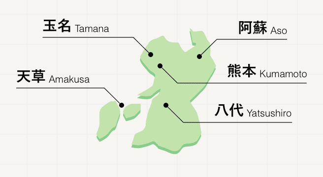
Kumamoto lies in the center of Kyushu, a calm prefecture perfect for easy strolls around the historic center and lazy evenings in the natural hot springs at Kurokawa Onsen. For a slightly more strenuous activity, head to Mount Aso, whose surrounding hills offer hiking opportunities aplenty with views over the active volcano.
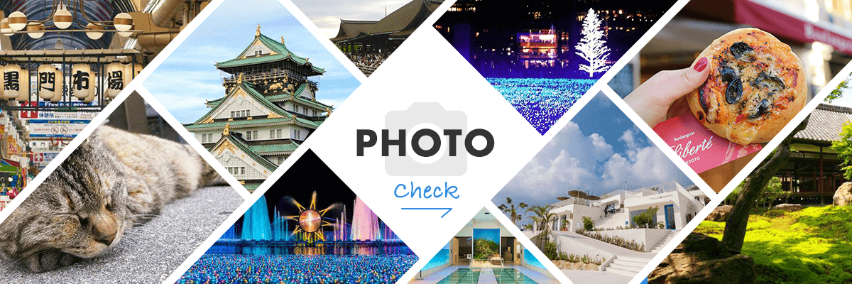
Kumamoto Photo Album
Best of Kumamoto
Search by Region
-
- Hokkaido / Tohoku
- Hokkaido
- Aomori
- Iwate
- Miyagi
- Akita
- Yamagata
- Fukushima
-
- Kanto
- Ibaraki
- Tochigi
- Gunma
- Saitama
- Chiba
- Tokyo
- Kanagawa
-
- Koshinetsu / Hokuriku
- Niigata
- Toyama
- Ishikawa
- Fukui
- Yamanashi
- Nagano
-
- Tokai
- Gifu
- Shizuoka
- Aichi
- Mie
-
- Kinki
- Shiga
- Kyoto
- Osaka
- Hyogo
- Nara
- Wakayama
-
- Chugoku
- Tottori
- Shimane
- Okayama
- Hiroshima
- Yamaguchi
-
- Shikoku
- Tokushima
- Kagawa
- Ehime
- Kochi
-
- Kyushu / Okinawa
- Fukuoka
- Saga
- Nagasaki
- Kumamoto
- Oita
- Miyazaki
- Kagoshima
- Okinawa


