Nature Spots in Kumamoto Area
Area
-
-
Kumamoto


-
-
Kumamoto

Category
-
- Kikuchi Gorge
-
![rating-image]() 4.5156 Reviews
4.5156 Reviews - Travel / Tourism
- Kumamoto Pref. Kikuchishi Haru
- It is located approximately 50 minutes away from the Ueki Interchange on the Kyushu Expressway. This gorge stretches within the Aso-Kuju National Park, and is a scenic area that has been selected as one of the Top 100 Forested Valleys in Japan, the 100 elections of the waterfall in Japan and the Top 100 Famous Water. Also known as Kikuchi Suigen, the underground water of Mt. Asogairin, which flows between a broadleaf forest, creates various lakes and waterfalls of various sizes, creating a landscape filled with variety. The average water temperature in the summer is 13 degrees Celsius, so it is called a natural cooler and is popular as a summer resort area. You can enjoy fresh greenery in the spring, colorful leaves in the autumn and frosty flowers that bloom over the whole mountain in the winter.
-
![]()
The blueish color from the water is very beautiful. It was so refreshing feeling the cool air from the waters.

-
- Ikeyama Suigen (Spring Source)
-
![rating-image]() 4.582 Reviews
4.582 Reviews - Travel / Tourism
- Kumamoto Pref. Asogunubuyamamura Tajiri 14-1
- This spring water was selected as one of Japan’s top 100 waters. With the Mt. Juku range at its source, each minute it pumps out 30 tons of water and many people come to draw from it. The water temperature remains around 13 degrees throughout the year. It is water representative of the Aso area, with a mild taste.
-
![]()
We walked from the other side of hills on a very sunny day...we finished about 1 gallon of water when we finally got there... We passed several herds of cows gazing and it was scary because they...

-
- Mt. Daikanbo
- Travel / Tourism
- Kumamoto Pref. Asoshi Yamada
- A 936 meter high mountain located on the highest peak of the outer rim of the north crater of Mt. Aso. In ancient times, it was called Tomigahana (the nose looking into the distance), but the great author Tokutomi Soho dubbed it Daikanbo (great overviewing mountain) after being moved by the magnificent view. The mountain offers a sweeping view of the five peaks of Mt. Aso, the Kuju Mountain Range, and the Aso Caldera. The controlled burns conducted in spring are held on an impressive scale.

-
- Oshitoishi
-
![rating-image]() 4.067 Reviews
4.067 Reviews - Travel / Tourism
- Kumamoto Pref. Asogunminamiogunimachi Nakabaru 511
- This is a stone culture ruin dotted with huge megaliths named sun stones, and Cuneiform script-engraved mirror stones. If one borrows a compass from the management center and takes a walk around, the strong magnetic field means the needle which should by all rights be pointing North begins to swing creating quite an unsettling experience! It’s a spot where one can enjoy the beauty of nature including views of Mt. Kuju and Mt. Aso.
-
![]()
広大な台地が広がる丘の上に、幾つかの大きな石が転がっているところです。シュメール文字?が刻まれている鏡石、祭壇石、磁気を発する押戸石、はさみ石など。周りを360度見渡せて、周りに広がる広大な大地がきれいです。遠くには阿蘇の山々が見られます。環境整備費として一人200円必要ですが、とても眺めの良いところです。進撃の巨人のロケ地となったそうです。

-
- Kusasenrigahama Beach
- Travel / Tourism
- Kusumoto-ken, Aso City, Kusaki-igahama
- A prairie located in the remains of a caldera at the foot of Mt. Eboshi, one of the five peaks of Mt. Aso. The location is known for its picturesque and idyllic scenery—horses and cows freely graze in the area against the backdrop of the mountain’s smoking middle peak. Considered one of the most representative sights in the Aso area, many people come here to enjoy the atmosphere.

-
- Nabegataki Falls
- Travel / Tourism
- Kumamoto Pref. Asogunogunimachi Kurobuchi
- This is a waterfall which is said to have been made by an eruption which occurred about 90,000 years ago, which also created Aso’s caldera lake. This is a small waterfall with a height of about 10 meters and a width of about 20 meters, but the appearance of sunlight shining through the curtain-like broadly cascading water is extremely beautiful. “Urami no taki” which is enjoying the waterfall by going around to the other side of the fall is also popular. An event is also held in the springtime in which the far side of the waterfall is illuminated.

-
- Shiramizu Falls
-
![rating-image]() 4.518 Reviews
4.518 Reviews - Travel / Tourism
- Oita Taketa-shi
- "A waterfall located in Hinatame, Ogi-machi, Taketa City. Situated along the Ono River, the waterfall's name means ""white water,"" and there are two theories as to how it got this name. One is that it is because the waterfall appears white due to its numerous streams; the other is that because it is comprised of 99 streams, its name was written with the character for ""100"" minus a line at the top representing ""one,"" resulting in the character for ""white."""
-
![]()
茶屋が休みの日(水曜日)だったのと15時ぐらいだったのでかなりすいてました。 滝までは段々進むほど急坂で少しきつかったです。 滝に到着したとき、静寂さと空気のおいしさに驚きました。(こんな気分ははじまて) 戻りしな母滝を撮してるときに山肌にある2つの蜂の巣に気づきました。 それ以降、なんか1,2匹の蜂が気になりました 吊り橋もよかったです。

-
- Shirakawa Suigen Spring Source
- Travel / Tourism
- Kumamoto Pref. Asogunminamiasomura Shirakawa 2092-1
- This is a first-class river (a specified waterway of special importance protected by the government) which flows through the centre of Kumamoto City. It is classic example of Minami Aso spring water, and it was also selected as one of the 100 best waters in Japan by the Environmental Agency. The normal temperature of this spring water is 14°C and 60 tons per minute gushes out into the Shirakawa River, and it is possible to take spring water from the source home. Heat treated water is also for sale.

-
- Shiraito Falls
- Travel / Tourism
- Kumamoto Pref. Asogunnishiharamura Kawahara
- Shiraito Falls, where water drops in a single stream from 20 meters high, is so named as the flow looks like a white thread, or “shiraito.” The beautiful, clear water has been selected as one of Kumamoto Prefecture’s top 100 waters of the Heisei era. In the summer season illuminations are held until 10pm, and at the nearby Shiraito Falls Exchange Center one can enjoy somen nagashi (flowing somen).

-
- Soyo Gorge
-
![rating-image]() 4.014 Reviews
4.014 Reviews - Travel / Tourism
- Kumamoto Pref. Kamimashikigunyamatochou Nagasaki
- "A gorge situated along the upper reaches of the Gokase River. This gorge is famous for its ""U"" shape, a rarity in Japan. The gorge's precipitous walls, carved out via erosion, are some 200 meters tall and extend across a 10 kilometer stretch of the river. If you visit the Cape Nagasakibana Observatory and look down on the gorge, you can take in a view of the Gokase River weaving its way through the gorge bottom as well as the seasonal scenery of the so-called ""Grand Canyon of Kyushu."" Particularly from late October to early November, the area's fall foliage is stunning. The Soyo Gorge fall foliage festival, usually held in mid-November, is quite popular."
-
![]()
この道で大丈夫かなと不安になるような道をひたすらまっすぐ。やっと到着と思ったら、落葉!残念!綺麗な紅葉は望めませんでしたが、景色はよかった。

-
- Mt. Aso Nakadake
- Travel / Tourism
- Kumamoto Pref. Asoshi Ichinomiyamachimiyaji
- One of the peaks which make up Mt. Aso, it is 1,506 meters high. Situated in the almost exact center of the central group of volcanic cones, this peak is the most active of the volcanos of Aso. Its craters are numbered one through seven, and there is a caldera lake - a crater in which rainwater and spring water has accumulated - known as Yudamari. Access to the lake area may be restricted at times due to the emission of volcanic gasses.

-
- Hakoishi Pass
- Travel / Tourism
- Kumamoto Aso-shi
- This pass is situated along National Route 265 on the way from Ichinomiya Town to Takamori Town. Here visitors can enjoy a variety-rich winding road while taking in views of the grassy plains of Aso on either side. The sight of the dynamic road passing in front of Mt. Neko, one of the five peaks of Mt. Aso, is reminiscent of the Great Wall of China. The scenery which sprawls away into the distance at the top of the winding pass is famous amongst motorcycle riders and amateur photographers. The pass was awarded a Special Prize by the Kumamoto Kando Project, a project which seeks to discover new Kumamoto sightseeing destinations for a new age.

-
- Ichifusa Dam Lakeshore
- Travel / Tourism
- Kumamoto Pref. Kumagunmizukamimura Yuyama
- "Ichifusa Dam was built in 1960 in Mizukami Village, Kuma County, Kumamoto Prefecture. Yoshino cherries were planted around the dam lake when the dam was built, and today the lakeshore is a renowned destination for viewing cherry blossoms in spring. The area's ""10 thousand"" cherries sprawl along the shore for 14 kilometers, and visitors can appreciate their beautiful blossoms. A cherry blossom festival is also held here during the season, and a portion of the trees are lit up at night to delight visitors."

-
- Mt. Aso Nakadake Crater
- Travel / Tourism
- Kumamoto Aso-shi Kurokawa
- Mt. Aso is the central volcanic cone group of the calderas, some of the largest in the world, located in Kumamoto Prefecture's Aso region. The five peaks of Mt. Aso span 17 kilometers east-west, 25 kilometers north-south, and occupy some 350 quare kilometers in area, but of them, today only Mt. Naka is active. The crater lake in Mt. Naka's primary crater was formed by the collection of rain and spring water in the crater bottom and is one of only a few places in the world where visitors can experience volcanic activity up close. The entire area is finely divided into numerous zones, and access to each area is permitted or prohibited based on the volcano's activity and the direction of the winds. The emerald green waters of the crater lake, created due to colloidal sulfur and iron ions dissolved into them, is a truly mystical site which speaks of the natural forces at play deep inside the planet.

-
- Komezuka
- Travel / Tourism
- Kumamoto Pref. Asoshi Nagakusa
- A 954 meter tall mountain. Although small, the mountain’s shape is quite lovely; the crater at the top is the remains of a volcanic caldera. Verdant in early summer and desolate in winter, the mountain is popular for its highly seasonal appearance.

-
- Okoshiki Beach
- Travel / Tourism
- Kumamoto Pref. Utoshi Shimoodamachi
- "A coastal area located in Uto City. Literally translated, ""Okoshiki"" means ""palanquin,"" a name that is derived from a legend which states that when Emperor Keiko toured Kyushu, his eyes were arrested by the beauty of the coastline and he ordered his palanquin to stop. The scenery has been selected for inclusion in a list of Japan's 100 best beaches and 100 best sunsets. On clear days, visitors can see all the way to Mt. Fugen in Nagasaki on the opposite shore. The ebb and flow between the tides here is also the greatest of any location in Japan, and during the ebb tide, the exposed sands create beautiful curing patterns."

-
- Senomoto Highland
- Travel / Tourism
- Aso-gun, Kumamoto Pref.
- A highland located between the outer northern crater rim of Mt. Aso and the Kuju Mountain Range. Known for the scenic Yamanami Highway, the area also bustles with visitors come to pick edible wild plants like bracken, and, in fall, to view the gorgeous autumn foliage. There are also rest houses, lodges, campgrounds, and hot spring bathhouses in the area.

-
- Reigando Cave
-
![rating-image]() 5.01 Reviews
5.01 Reviews - Travel / Tourism
- Kumamoto Pref. Kumamotoshinishiku Matsuomachihirayama 589 Unzen Temple
- "A cave located in Nishi Ward, Kumamoto City. Situated at the foot of Mt. Kinbo, a statue of the Buddhist deity Kannon known as the ""Iwato Kannon"" is enshrined in the cave. The cave is also known as the place where the great warrior Miyamoto Musashi spent the last five years of his life writing ""The Book of Five Rings."""
-
![]()
霊巌洞に向かう道に五百羅漢さんが、武蔵の時代から150年後に奉納されたものです。 金峰山は火山で幾多の大小地震で、頭部の落ちたものが多いです。 洞窟内には観音像があります。

-
- Sunasenrigahama
- Travel / Tourism
- Aso City, Kumamoto Prefecture Aso Mountain, Kurokawa
- A natural landscape located in Aso City. At the site of an ancient caldera situated southeast of the Nakadake Crater on Mt. Aso, visitors can take in scenery consisting of a continuous stretch of black sands. The site serves as a contrast to the picturesque grassland known as Kusasenrigahama, also on Mt. Aso. Access may be restricted at times due to volcanic gasses emitted by Mt. Aso.

-
- Myokenura Coast
- Travel / Tourism
- Kumamoto Pref. Amakusashi Amakusamachishimodaminami
- "A 50-minute drive from Amakusa Airport, this scenic spot on the west coast of Amakusa has been designated as a national scenic spot and a natural monument. The coastal area has a stretch of 20 to 80-meter high cliffs, which together with large and small islands, reefs and caves form a unique landscape. The largest, ""Myonken Domon"" cave mouth, can be easily accessed by small boats, and you can see sea caves and stalactites that cross each other. The scenery at dusk is even more remarkable, and the view from nearby Nishibiratsuki Park and the Kikaigaura Observation Deck has been selected as one of the Japan Sunset Best 100."


Kumamoto Areas
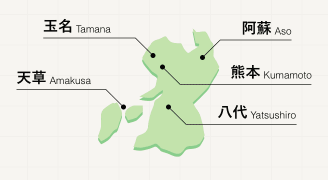
Kumamoto lies in the center of Kyushu, a calm prefecture perfect for easy strolls around the historic center and lazy evenings in the natural hot springs at Kurokawa Onsen. For a slightly more strenuous activity, head to Mount Aso, whose surrounding hills offer hiking opportunities aplenty with views over the active volcano.
Kumamoto Photo Album
Best of Kumamoto
Search by Region
-
- Hokkaido / Tohoku
- Hokkaido
- Aomori
- Iwate
- Miyagi
- Akita
- Yamagata
- Fukushima
-
- Kanto
- Ibaraki
- Tochigi
- Gunma
- Saitama
- Chiba
- Tokyo
- Kanagawa
-
- Koshinetsu / Hokuriku
- Niigata
- Toyama
- Ishikawa
- Fukui
- Yamanashi
- Nagano
-
- Tokai
- Gifu
- Shizuoka
- Aichi
- Mie
-
- Kinki
- Shiga
- Kyoto
- Osaka
- Hyogo
- Nara
- Wakayama
-
- Chugoku
- Tottori
- Shimane
- Okayama
- Hiroshima
- Yamaguchi
-
- Shikoku
- Tokushima
- Kagawa
- Ehime
- Kochi
-
- Kyushu / Okinawa
- Fukuoka
- Saga
- Nagasaki
- Kumamoto
- Oita
- Miyazaki
- Kagoshima
- Okinawa


