Mountain Spots in Niigata Area
Area
-
-
Niigata


-
-
Niigata

Category
-
- Mt. Naeba
- Travel / Tourism
- Nigata Pref. Minamiuonumagunyuzawamachi Mikuni
- This volcano stands 2,145 meters tall at the boundary between Niigata and Nagano Prefectures. Located in Joshinetsu-Kogen National Park at its summit is Ime-jinja Shrine which has long drawn those looking to befriend the god of rice cultivation. Near the summit spreads a wetland where you can see all sorts of beautiful alpine plants including the Miyama-bulrush. This beauty has led to the area being selected by the Ministry of the Environment as one of Japan's 500 important wetlands. During the winter the ski-slope at the foot of the mountain draws lots of visitors. Different mountain climbing routes are being developed and between late-June and mid-October lots of mountain climbing visitors flock to the mountain.

-
- Mt. Kakuda
- Travel / Tourism
- Niigata Prefecture Nishi-ku, Niigata City
- This 481.7-meter mountain is located in Nishikan Ward, Niigata City. It has the designated Sado-Yahiko-Yoneyama Quasi-National Park, with abundant nature that allows visitors to observe much of the vegetation that grows naturally in the prefecture, including flowers such as Primula modesta and Asian fawnlily, which bloom in the spring. There are seven maintained mountain trails here, and visitors can see the Sea of Japan and Sado Island from the summit.

-
- Mt. Makihata
- Travel / Tourism
- Nigata Pref. Minamiuonumashi Shimizu
- This 1967-meter mountain sits between Minamiuonuma City, Niigata Prefecture and Minakami Town, Tone County, Gunma Prefecture. There is an intermediate-level mountain climbing route with an elevation difference of approximately 1,500 meters, and in addition to the view from the summit of the mountain, visitors can also enjoy wonderful natural sights such as the alpine plants, ponds (marshlands), and the waterfalls and strange rocks of Waribikisawa. It has been selected as one of 100 Famous Japanese Mountains.

-
- Mt. Donden
- Travel / Tourism
- Niigata Sado-shi Nyugawa
- Although its formal name is Tadara Peak, people call the round mountain at the highest point of the highland that consists of the three mountains of the Osado Range “Mt. Donden” (“Blunt Ridge”). As its name suggests, it is the only mountainous area with a gentle, rounded shape in the otherwise steep Osado Mountain Range. The highland, where free-range cattle sometimes can be seen on the parking lot, is abundant high-altitude plants and grasses. It is numbered among the New 100 Most Famous Mountains in Japan and the 100 Best Flower Mountains in Japan. The most popular season for visitors is spring to early summer, when trekkers flock here to see unusual varieties of rhododendron brachycarpum, Japanese azaleas, and Menziesia multiflora.

-
- Mt. Yahiko
- Travel / Tourism
- Yahiko village Nishikanbara gun Niigata ken
- This is the highest peak of the Yahiko Mountain Range which sits on the Echigo Basin alongside the Sea of Japan. It stands 634 meters above sea level, the same height as the Tokyo Sky Tree, and the silhouette of its peak is one of its key features. In the afterwards of Fukada Kyuya's book 100 Famous Japanese Mountains he states that while the height of the mountain might be lacking it has to be included. The ropeway on the Mt. Yahiko Skyline is both great ways to access the summit. The mountain is used for excursions by the local elementary and middle schools and is recommended for beginner mountain climbers. From the summit you have a great view of everything from the Sea of Japan to the Echigo Basin and the site of the sunset over Sadogashima Island is highly regarded.

-
- Sasagamine
- Travel / Tourism
- Sasagamine in Myoko City Niigata Prefecture
- A mountain rising approximately 1,545 meters above sea level to the southwest of Mt. Myoko. You can see the grassland dotted with trees; a sight similar to a forest in a foreign country. Not only the facilities such as trekking courses, campgrounds, ranches, and Sasagamine Dam are in place, the area is also famous as a location for TV commercials.

-
- Mt. Sakado
- Travel / Tourism
- Nigata Pref. Minamiuonumashi Sakado
- Mt. Sakado is a 20-minute walk from Muikamachi Station. As the ancient site of Sakado Castle the mountain has become symbolic to the people of Minamiuonuma City. Standing 634 meters high there is a hiking course from the base to the summit that takes approximately one hour. Of the four fields of dogtooth violets in the city this is the most popular. The best time to see them is from early-April to early May and as you hike from the base to the summit you can enjoy the flowers dotting the landscape including anemones, asteroids, and oriental swamp pinks along with the dogtooth violets. From the summit you can see the mountains all the way along the Joetsu border to the Uonuma Basin.
-
- Mt.Nokogiri
- Travel / Tourism
- Niigata
-
- Mt.Yamamoto (Prefectural Nature Park)
- Travel / Tourism
- Niigata Ojiya-shi Yama Motoyama
-
- Mt.Kugami
- Travel / Tourism
- Niigata Tsubame-shi Kugami

-
- Mt.Hachigadake
- Travel / Tourism
- Niigata
-
- Mt.Korenge
- Travel / Tourism
- Niigata
-
- Mt.Inugatake
- Travel / Tourism
- Niigata
-
- Mt.Hokogatake
- Travel / Tourism
- Niigata
-
- Mt.Hishigatake
- Travel / Tourism
- Niigata
-
- Mt.Myojo
- Travel / Tourism
- Niigata
-
- Mt.Saburyu
- Travel / Tourism
- Niigata
-
- Mt.Mantaro
- Travel / Tourism
- Niigata
-
- Mt.Nakanodake
- Travel / Tourism
- Niigata
-
- Mt.Kurohime
- Travel / Tourism
- Niigata

Niigata Areas
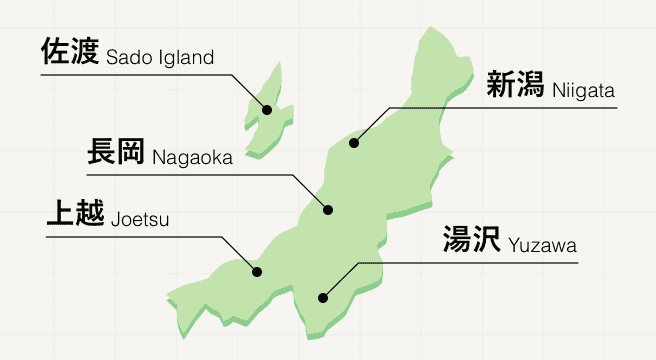
Found along the northwestern coast of Japan, Niigata prefecture is celebrated for its high-quality rice and breathtaking nature, most notably its spectacular mountains, whose white peaks draw in snow sports lovers from far and wide over the winter months. Hit the slopes at Yuzawa, pick out your favourite modern artist at Echigo Tsumari, or take a ferry over to Sado Island for an extra adventure.
Niigata Photo Album
Best of Niigata
Search by Region
-
- Hokkaido / Tohoku
- Hokkaido
- Aomori
- Iwate
- Miyagi
- Akita
- Yamagata
- Fukushima
-
- Kanto
- Ibaraki
- Tochigi
- Gunma
- Saitama
- Chiba
- Tokyo
- Kanagawa
-
- Koshinetsu / Hokuriku
- Niigata
- Toyama
- Ishikawa
- Fukui
- Yamanashi
- Nagano
-
- Tokai
- Gifu
- Shizuoka
- Aichi
- Mie
-
- Kinki
- Shiga
- Kyoto
- Osaka
- Hyogo
- Nara
- Wakayama
-
- Chugoku
- Tottori
- Shimane
- Okayama
- Hiroshima
- Yamaguchi
-
- Shikoku
- Tokushima
- Kagawa
- Ehime
- Kochi
-
- Kyushu / Okinawa
- Fukuoka
- Saga
- Nagasaki
- Kumamoto
- Oita
- Miyazaki
- Kagoshima
- Okinawa


