Nature Spots in Western Area Area
Area
-
-
Gunma


-
-
Gunma

Category
-
- Lake Haruna
- Travel / Tourism
- Gunma Pref. Takasakishi Harunakomachi
- This lake is located on the western side of Mt. Haruna, one of the “Three Mountains of Jomo.” It is a crater lake formed by eruptions from Mt. Haruna, and it is at an altitude of approximately 1,100 meters. It is known for its gorgeous view of the central volcanic cone of Mt. Haruna, which is often called “Haruna Fuji,” and it features in many outdoor activities, including pleasure cruise tours, motor home camping, hill-climb races, and other leisure and sports events.

-
- Lake Usui
-
![rating-image]() 3.546 Reviews
3.546 Reviews - Travel / Tourism
- Gunma Pref. Annakashi Matsuidamachisakamoto
- "Lake Usui is a man-made lake that was created when the confluence of the Nakao River and the Usui River was dammed by the construction of the Sakamoto Dam; it is located around 10 minutes' drive from Yokokawa Station on the JR Shinetsu Line. The lake is surrounded by state-owned forest, and presents a beautiful appearance at any time of year; it is particularly spectacular in autumn, when the autumn foliage of the surrounding trees is reflected in the Lake. There is a roughly 1.2 kilometer long footpath around the lake, which takes approximately 20 minutes to walk round. Lake Usui is situated part-way along the ""Apt Road,"" a hiking path that follows the route of a disused railway line. The bright red bridge that crosses the Lake was constructed as an arched bridge."
-
![]()
中山道より脇道のそれると湖畔の駐車場にたどり着く事出来ます。舗装された駐車場と整備されたトイレがあり、景色も良くドライブ中の休憩地としては最適だと思います。

-
- Mt. Haruna
- Travel / Tourism
- Gunma Pref. Takasakishi Harunakomachi
- A 1,449 meter tall mountain located in Takasaki City, Gunma Prefecture and one of the Three Mountains of Jomo. At the top of the mountain are Lake Haruna, a caldera lake, and the Haruna-Fuji lava dome central volcanic cone. A ropeway takes visitors to the top in around three minutes, and from here you can get a sweeping view of the Kanto Plain and the mountains of the Joshu area. Many events are also held here and in winter visitors can enjoy the magical site of the Lake Haruna during the Illumination Festa nighttime illumination festival.

-
- Hanekoshi Gorge
- Travel / Tourism
- Gunma Pref. Kanragunshimonitamachi Hakusan
- """This gorge is along the Nishi-Joshu Yamabiko Highway in Hakusan, Shimonita Town, Kanra County. Carved by the flow of the Kabura River, the gorge's narrow width gives it the name ""Hanekoshi,"" which means ""leaping over"" in Japanese. It's part of the Shimonita Geopark as recognized by the Japan Geopark Committee."

-
- Usui Pass
- Travel / Tourism
- Gunma Pref. Annakashi Matsuidamachisakamoto
- The Usui Pass, on the border of Gunma and Nagano prefectures, at elevation 960 meters, was considered an essential pass connecting Kanto area with the Shinano and Hokuriku areas. At its peak, on the border, are located the Kumanokoutai-jinja Shrine and Miharashidai lookout known as an excellent Sunset Point. In recent years, it has become popular as a tourist area with the Usui Pass Railway Culture Park, the Abt Walking Path, the Lake Usui, and the Megane Bridge across the Usui River, all nearby.
-
- Mt. Myogi
- Travel / Tourism
- Gumma prefecture Tomioka city, Annaka city, Rakuraku-gun Shimonita cho
- Consider to be one of Japan’s Top 3 Strange Views, this 1,100-meter-elevation mountain spans Tomioka City, Annaka City, and Shimonita Town in Gunma Prefecture. The views over the Kanto Plain—packed with wild and bizarre rocks—is wonderful. The best views come in early summer with the fresh green leaves, in autumn with fall leaves, and in spring with the “sakura-no-sato” and its 5,000 blooming cherry trees in 45 varieties.

-
- Kanna Lake (Gunma Prefecture)
- Travel / Tourism
- Gunma Pref. Fujiokashi Hominoyama Kamigawa-gun, Kodama-gun, Saitama Prefecture,
- This reservoir at the border of Gunma Prefecture and Saitama Prefecture is formed where the Shimokubo Dam impedes the Kanna River. There are hiking trails and a campsite in the vicinity to help you enjoy the natural wonders of Chichibu-Tama-Kai National Park. The Sanbaseki Gorge is located downstream. It has been designated a Natural Monument as well as a Place of National Scenic Beauty.

-
- Mt. Haruna-fuji
- Travel / Tourism
- Gunma Pref. Takasakishi Harunakomachi
- Mt. Haruna-fuji is the 1,390-meter-high central volcanic cone in the summit caldera of Mt. Haruna—one of Three Mountains of Jomo. Resembling the beautiful shape of Mt. Fuji, the natural landscape of the mountain reflected in the lake is symbolic of Gunma Prefecture. There is a ropeway serving Mt. Haruna-fuji, one that offers a tremendous view of the gigantic Kanto Plain.

-
- Jukkoku Pass
- Travel / Tourism
- Gunma Prefecture Tano-gun Uenomura
- This mountain pass is 1,351 meters in height and is located between Ueno Village, Tano County in Gunma Prefecture and Sakuho Town, Minamisaku County in Nagano Prefecture. This name of the pass originates from a long time ago when 1,500 kilograms (Jikkoku) of rice had to be carried every day from the Shinshu region to the west of Joshu region where rice could not be harvested. In addition to rice, miso paste and soy sauce from the Shinshu region and coal from the Shinshu region was transported. The folk song, “Jikkoku-Mago-Uta”, sung by the horsemen is passed down to this day. At the Jikkoku Pass, there are car parks, toilets, and a tower observatory with a magnificent view, that can be entered freely. Please be aware that the mountain pass is closed during winter.

-
- Fujido Cave
- Travel / Tourism
- Gunma Pref. Tanogunuenomura Kawawa 665
- 2.2 kilometers long, this is one of the largest tourist caves in the Kanto region, located within Kawawa Natural Park of Ueno Village, Tano County, Gunma Prefecture. Discovered roughly 1,200 years ago, the first to reach the end of the cave was a monk from Fujiwarayama Kichijoji Temple 400 years ago. The temperature inside remains around 10°C year-round. Illuminated by LED lights for a mysterious feel, bringing in many visitors.

-
- Mt. Osutaka
- Travel / Tourism
- Gunma Prefecture Tano-gun Uenomura
- This is a 1,639 meters high mountain in Ueno Village, Tano County in Gunma Prefecture. The south side of the mountain borders Nagano Prefecture and Mt. Osutaka stands at the border with the mountain ridge on the Gunma side. At the summit is a third-class triangulation point called Mt. Taishaku. The mountain neighbors three other mountains called Mt. Takamagahara, Mt. Suwa and Mt. Ogura, all rated as intermediate level mountains to climb. Also, the memorial monument for the Japan Airlines 123 flight crash that occurred on August 12 in 1985, stands at the point known as “Osutaka-no-One”.

-
- Nidoage Pass
- Travel / Tourism
- Gunma Prefecture Takasaki City
- This is a pass on the border of Takasaki City, Gunma Prefecture and Naganohara Town, Agatsuma County, opened with an altitude of about 1,380 meters and rich in nature. It is recommended for those visiting Asama-Otaki Falls and Asama Ranch as there is a car park for climbers. The view of Mt. Asama from Nidoage Pass is spectacular, especially during autumn when you can enjoy the scenery of the changing colors of the leaves. The beautiful scenery makes it a popular course for those driving or motorbike riding to Kita-Karuizawa.

-
- Sandan Falls
- Travel / Tourism
- Around 1264 Minamimaki-mura, Ganura-gun, Gunma Prefecture
- "This waterfall is part of a river in Nanmoku Village, Kanra County, Gunma Prefecture. The cascade drops 50 meters, falling over three levels, ""sandan"" in Japanese. It's accessible via a parking lot on Prefectural Route 108. A walkway leads to the waterfall with a few kilometers' hike. It's not entirely flat, so you need to be careful. Along the valley leading to Sandan Falls you'll encounter numerous other cascades both large and small."

-
- Uchiyama Pass
- Travel / Tourism
- Nagano Pref. Sakushi Uchiyama
- A pass known as the trailhead of Mt. Arafune located on the border between Kanra County, Gunma Prefecture and Saku City, Nagano Prefecture along National Route 254. Visitors can view picturesque rock formations such as Himeiwa Rock, Byobuiwa Rock, and Napoleon Rock as well as lush natural, seasonal scenery, and the pass has been selected as possessing one of the 100 most picturesque sunsets in Nagano.

-
- Sannami Seki Valley
- Travel / Tourism
- Gunma Fujioka-shi Yuzurihara 1608

-
- Shimokubo Dam
- Travel / Tourism
- Saitama Kodama-gun Kamikawamachi
-
- Mt.Akaguna
- Travel / Tourism
- Gunma
-
- Mt.Nishimikabo (Mt.Mikabo)
- Travel / Tourism
- Gunma
-
- Mt.Soma (Mt.Myogi)
- Travel / Tourism
- Gunma
-
- Mt.Hanamagari
- Travel / Tourism
- Gunma


Gunma Areas
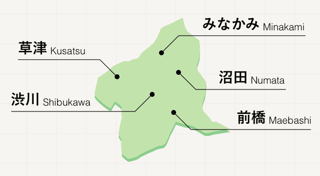
Gunma prefecture is synonymous with onsen. Natural hot spring water sources throughout the prefecture have given rise to a series of small onsen towns, each set among luscious mountains. At Kusatsu, Ikaho, and Minakami, traditional indoor and outdoor bathing experiences are served hand in hand with irresistible onsen-themed food, including steam-cooked eggs and custard pudding.
Gunma Photo Album
Best of Gunma
Search by Region
-
- Hokkaido / Tohoku
- Hokkaido
- Aomori
- Iwate
- Miyagi
- Akita
- Yamagata
- Fukushima
-
- Kanto
- Ibaraki
- Tochigi
- Gunma
- Saitama
- Chiba
- Tokyo
- Kanagawa
-
- Koshinetsu / Hokuriku
- Niigata
- Toyama
- Ishikawa
- Fukui
- Yamanashi
- Nagano
-
- Tokai
- Gifu
- Shizuoka
- Aichi
- Mie
-
- Kinki
- Shiga
- Kyoto
- Osaka
- Hyogo
- Nara
- Wakayama
-
- Chugoku
- Tottori
- Shimane
- Okayama
- Hiroshima
- Yamaguchi
-
- Shikoku
- Tokushima
- Kagawa
- Ehime
- Kochi
-
- Kyushu / Okinawa
- Fukuoka
- Saga
- Nagasaki
- Kumamoto
- Oita
- Miyazaki
- Kagoshima
- Okinawa


