Mountain Spots in Miyagi Area
Area
-
-
Miyagi


-
-
Miyagi

Category
-
- Mt. Kattadake (Mt. Zao)
- Travel / Tourism
- Miyagi Prefecture
- A mountain located on the border between Miyagi Prefecture and Yamagata Prefecture. This is the third highest mountain in the Zao Mountain Range with an altitude of 1,758 meters. The Zao High Line mountain toll road is open from the end of April to the beginning of November, making it possible to drive up close to the summit. From the end of October until the official closing date, it's impassable at night, too. Kattamine-jinja Shrine's mountain sanctuary is on the summit, as well as a stone monument in recognition of Date Munetaka's great achievements; he prayed here at the time of a large eruption. There's also a view of Okama crater lake at Mt. Goshikidake just a five-minute walk from the parking lot. The color of the water changes dramatically depending on the weather.

-
- Mt. Anba
- Travel / Tourism
- Miyagi Pref. Kesennumashi Machiura
- A 239 meter tall mountain with a sweeping view of Kesennuma Bay and the streets of Kesennuma which serves as a symbol of the city. Visitors can drive a car partway up the mountain; the top of the mountain is a 15 minute walk from the highest parking area. Anbasan Park, created in the image of a dragon, is located near the top of the mountain, and visitors are greeted by two dragon statues at the entrance. The mountain is also popular because of its night view.
-
- Tamonzan
- Travel / Tourism
- Miyagi Miyagi-gun Shichigahama Machi Yogasakihama Hachigamori
- "A 55.6 meter high mountain located on the northern tip of Shichigahama Town a 20 minute drive from Tagajo Station on the JR Senseki Line. The mountain's sweeping view of the more than 260 islands floating in Matsushima Bay is called the ""Bikan"" (or ""Ikan,"" ""Beautiful View/Magnificent View""), one of the Four Views of Matsushima, four spectacular views which also include the ""Sokan"" of Mt. Otakamori in Higashimatsushima City, and the ""Reikan"" of Mt. Tomi and ""Yukan"" of Ogitani in Matsushima Town. The surrounding area is maintained as Tamonzan Tenbo Hiroba Park. A walking path in the park leads to the rear of the Bishamon-do Temple from which visitors can enjoy vast, majestic scenery immediately below encompassing Mahanashi Island, Jizo Island, and the other islands floating in Matsushima Bay."

-
- Mt. Tomiyama
- Travel / Tourism
- Miyagi Miyagi-gun Matsushimamachi Toyama
- This mountain is in Tomiyama, Tetaru, Matsushima Town, Miyagi County. On a 116. 8 meter mountain stands Daigyoji Temple, a temple devoted to Kannon, one of the three great Kannon temples of Oshu. Along with Otakamori, Mt. Tamon, and Ogitani, it is considered one of the four best spots for viewing the rocky islands of Matsushima.
-
- Mt. Tatsugane
- Travel / Tourism
- Miyagi Motoyoshi-gun Minamisanrikucho
- This sacred mountain is located on the board between Kesennuma City and Minami-Sanriku Town. The summit is the primary viewing spot in the town and offers a panoramic view of the Pacific Ocean and the rias-type coast. It is famous for its mountain azaleas, and in mid-May, they bloom so lushly that they seem to cover the whole mountainside. The contrast between the flaming red mountain and the blue ocean is a one of Sanriku’s greatest sights, something one cannot see anywhere else. There are 11 sutra mounds at the summit of the mountain, and they are said to have a deep connection to the Oshu Fujiwara clan of medieval daimyo.

-
- Mt. Otakamori
- Travel / Tourism
- Miyagi Pref. Higashimatsushimashi Miyato
- Named best of Matsushima’s four great sights, the observation platform at the peak of this small mountain offers a gorgeous panorama view. There is a precipitous coast, Saga Gorge, to the east, Matsushima Bay stretches from the west to the south, with views of the sea and islands dotting in a beautiful scene. The north holds a broad view of Ishinomaki townscape.

-
- Mt. Kurikoma
- Travel / Tourism
- Miyagi Pref. Kuriharashi Kurikoma
- Mt. Kurikoma is 1,626 meters high and overlaps the three prefectures of Akita, Iwate and Miyagi. The Sukawa Highland halfway up is famed for the hot springs bubbling up and steaming away, and the green spring beech trees give way to beautiful reds and yellows in fall, for year round beauty.

-
- Mt. Tokusenjosan
- Travel / Tourism
- Miyagi Prefecture
- This 711-meter mountain is at the boundary between Kesennuma City and the former town of Motoyoshi. It's very famous for viewing azaleas from the middle to the end of May when the whole place bursts into a beautiful scene of red and green. With about 500,000 plants covering a range of 50 hectares, the colorful scenery reaches from the mountain summit to the Pacific Ocean. It takes about 45 minutes from the trail head to the summit, making it accessible to beginners as well, assuming they have the proper clothing and other hiking items. Expect big crowds on Saturdays and Sundays during the season. If you want to take your time and enjoy it, we recommend going on weekdays.

-
- Oshima Kameyama
- Travel / Tourism
- Miyagi Kesennuma-shi Kameyama

-
- Mt.Zao
- Travel / Tourism
- Miyagi
-
- Fubozan (Onmae Take)( Zaosan)
- Travel / Tourism
- Miyagi
-
- Mt.Aoso
- Travel / Tourism
- Miyagi
-
- Mt.Byobu (Mt.Zao)
- Travel / Tourism
- Miyagi
-
- Mt.Taihaku
- Travel / Tourism
- Miyagi
-
- Mt.Izumigatake
- Travel / Tourism
- Miyagi
-
- Mt.Yakurai
- Travel / Tourism
- Miyagi
-
- Kinkasan
- Travel / Tourism
- Miyagi
-
- Mt.Nonodake
- Travel / Tourism
- Miyagi
-
- Mt.Arao
- Travel / Tourism
- Miyagi
-
- Mt.Madonokura
- Travel / Tourism
- Miyagi Igu-gun Marumorimachi

Miyagi Areas
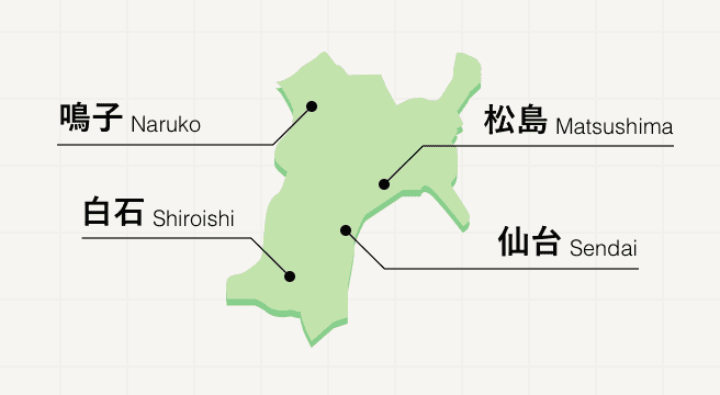
Lying along the northeastern coast of Japan, Miyagi prefecture is home to lashings of natural parks, oysters, and hot springs. While the bustling city of Sendai offers some simple city entertainment, it’s the Matsushima islands that deserve the most attention, having boosted the prefecture’s reputation as one of Japan’s most scenic views.
Miyagi Photo Album
Best of Miyagi
Search by Region
-
- Hokkaido / Tohoku
- Hokkaido
- Aomori
- Iwate
- Miyagi
- Akita
- Yamagata
- Fukushima
-
- Kanto
- Ibaraki
- Tochigi
- Gunma
- Saitama
- Chiba
- Tokyo
- Kanagawa
-
- Koshinetsu / Hokuriku
- Niigata
- Toyama
- Ishikawa
- Fukui
- Yamanashi
- Nagano
-
- Tokai
- Gifu
- Shizuoka
- Aichi
- Mie
-
- Kinki
- Shiga
- Kyoto
- Osaka
- Hyogo
- Nara
- Wakayama
-
- Chugoku
- Tottori
- Shimane
- Okayama
- Hiroshima
- Yamaguchi
-
- Shikoku
- Tokushima
- Kagawa
- Ehime
- Kochi
-
- Kyushu / Okinawa
- Fukuoka
- Saga
- Nagasaki
- Kumamoto
- Oita
- Miyazaki
- Kagoshima
- Okinawa


