Other Sightseeing Spots in Iwate Area
Area
-
-
Iwate


-
-
Iwate

Category
-
- Hachimantai Jukai Line
-
![rating-image]() 4.512 Reviews
4.512 Reviews - Travel / Tourism
- Iwate Hachimantai-shi
- This driving course runs along Prefectural Route 318 from Hachimantai City’s Matsukawa Onsen. You can drive through the nature of Hachimantai Plateau on the way to Hachimantai Aspite Line via Toshichi Onsen. Although it is closed during the winter, you can enjoy a snow corridor with snow on both sides of the road after it reopens.
-
![]()
松川温泉から藤七温泉を通り、アスピーテラインに繋がるルート。冬季通行止め。また冬季通行止めの前後期間は、路面凍結のため夜間通行止めとなるので、訪れる時には調べた方が無難です。アスピーテラインより空いています。 松川温泉から少し上ると、下倉スキー場の上級コースを横断します。クルマから見るこのコースは、信じられないほど急斜面に見えます。 景観はアスピーテラインより全体的に森が多く、少し劣るかもしれ...

-
- Hachimantai Aspite Line
- Travel / Tourism
- Iwate Pref. Hachimantaishi
- Hachimantai Aspite Line is a 27 kilometer driving course stretches from Iwate prefecture’s Hachimantai Gozaisho district to Akita Prefecture’s Toroko Onsen. It’s only open from mid-April to early November. From the time it opens to late April, the course is lined with snow to create a “Snow Corridor,” and in autumn the fall colors on Mt. Iwate and the surrounding forests offer an overwhelming sight. It’s 35 minutes’ drive from Tohoku Expressway Matsuo Hachimantai Interchange.

-
- Kitayamazaki Observatory
- Travel / Tourism
- Iwate Pref. Shimoheiguntanohatamura Kitayama 129-10
- This observatory is located in the village of Tanohata in Shimohei County, Iwate Prefecture. You can look out over Kitayamazaki, a scenic spot representative of the Sanriku coast. The observatory protrudes into the sea, with a wooden first observation desk, a powerful second observation desk, and third observation desk where you can go forest bathing. In addition, there are also stairs set up that lead down from the observatory to sea level. Enjoy the scenery of the eight-kilometer long dynamic coastline.

-
- Motsuji Temple Garden
- Travel / Tourism
- Iwate Pref. Nishiwaigunhiraizumichou Hiraizumi Osawa 58 Moshi Temple grounds
- A garden located a seven-minute walk from Hiraizumi Station on the JR Tohoku Main Line. The Motsuji Temple has been designated a Special Historic Site and a Special Place of Scenic Beauty and, together with the adjoining Pure Land Garden, is collectively referred to as the Motsuji Temple Garden. Oizumi ga Ike pond in the center of the garden is 180 meters from east to west and 90 meters from north to south, and is still the same shape as when it was first created. Goshuin seal marks are offered at the temple shop just past the main temple gate. At the Shofuan restaurant, you can rest legs tired from walking and enjoy soba noodles as well as sweets.

-
- Esashi Yume-no-Hashi Bridge
- Travel / Tourism
- Iwate Oshu-shi Esashi Iwayado
- An arch bridge over the Hitokabe River, connecting Tateyama Historic Park and Mukaiyama Park, famous for its cherry blossoms. Completed in 1999, Yume-no-Hashi (Dream Bridge) got its name because its construction was a dream come true for the locals. The highest part of the bridge is 50 meters above the river. It has a view of the Taneyama Highland to the east, downtown Esashi to the west, and the Yakeishi Mountain Range. The view of the bridge itself from below is also popular, often featuring in photos with cherry blossoms or the nightscape. Sightseeing spots including Esashi-Fujiwara Heritage Park and Esashi Native District Cultural Museum are close by.

-
- Kuramachi Mall
- Travel / Tourism
- Iwate Oshu-shi Esashinakamachi
- The Esashi region prospered thanks to water transport on the Kitakami River starting long ago. This walking street incorporates merchant storehouses and other features built during that period. It's at the Odori intersection on National Route 456 as you pass through Esashi, Oshu City heading towards the Hitokabe River. The street laid with flagstones and townscape with shops utilizing old warehouses will leave you feeling you've traveled back in time. A multitude of shops sell traditional local products such as egg noodles and Iwayado yokan (sweet bean paste jelly). It's a great spot to pick up some souvenirs of your trip.

-
- Kuma-no-hana Observatory
- Travel / Tourism
- Iwate Shimohei-gun Iwaizumicho Omoto
- "About 25 minutes by car from Ryusendo Cave. Extending from the south of the Omoto Coast, the tip of the peninsula is thought to look like a bear's nose, the literal meaning of ""kuma-no-hana.” It's covered with red pine trees that create a special beauty contrasting with the blue of the sea. It's one of the best viewpoints in Sanriku Fukko (reconstruction) National Park. The observatory is located about 800 meters from the national highway down a country road. There's a rest area too, as well as a parking lot a short distance from the lookout. The Omoto Coast's triangular Tatsuko-iwa Rock is worth seeing as well."

-
- Shijuhassaka Observation Deck
- Travel / Tourism
- Iwate Shimohei-gun Yamadamachi Funakoshi 1-77
- This observation deck is located a 150-minute drive from Kitakami-Ezuriko Interchange. It looks out to the Pacific Ocean and has an amazing view with a variety of landscapes between the shoreline and the horizon. In the past, it was known as a difficult place to visit with the many winding slopes that gave birth to its name of Shijuhachisaka (Forty-eight Hills), but it has now been made accessible by the opening of National Route 45, which serves as the southern gateway to Yamada Town. The bay is located on National Route 45, 33 kilometers from Miyako and 20 kilometers from Kamaishi, and has been recognized as one of the top eight views of Yamada. The view of the sea from the observation deck gives visitors the chance to see squid fishing and fishing fires in the summer.

-
- Shiyui Ohashi Bridge
- Travel / Tourism
- Iwate Shimohei-gun Tanohata Mura Sugenokubo
- About 15 minutes by bus from Tanohata Station, this bridge was named after the nearby Shiino-mori Forest. It connects parts of a well-known historic route and was inaugurated in accord with the wishes of forward-thinking local residents as well as thought of everyday life, a way of life, and the future. The bridge is 120 meters above the valley floor. It's one of the largest inverted arch bridges in the country, and the view of it with the surrounding mountains is beautiful.

-
- Ihatov Avenue Zaimoku-cho
- Travel / Tourism
- Iwate Morioka-shi Zaimokucho
- This street is located in Zaimoku-cho, Morioka City. Besides Kogensha (currently sells folk crafts) that published Kenji Miyazawa’s collection of fairy tales, “The Restaurant of Many Orders,” there are six monuments with motifs from Kenji Miyazawa's works such as the “Ishiza” sculpture of Kenji Miyazawa resting at a stone quarry along the street.

-
- Ichinohe Observatory
- Travel / Tourism
- Iwate Ninohe-gun Ichinohemachi
- This is located in Megashinden, Ichinohe Town in Ninohe County. In addition to being able to observe the starry night sky and sunspots through a 500-millimeter diameter telescope, visitors can also enjoy the adjacent planetarium. It is open on Fridays, weekends, and holidays between early May and mid-October.

-
- Gentaiwa Observation Deck
- Travel / Tourism
- Iwate Hachimantai-shi
- This observation space is located in the Matsuoyoriki Kitanomata National Forest in Hachimantai City. It is 1,200 meters high along the Hachimantai Aspite Line crossing through Hachimantai Plateau. You can enjoy spectacular views of Mt. Iwate and other surrounding mountains.

-
- Megane Bridge
- Travel / Tourism
- Iwate Pref. Tonoshi Miyamorichoushimomiyamori 30-37-1 Inside Miomi way street
- Megane (“Eyeglasses”) Bridge is a railroad bridge on the Kamaishi Line of the East Japan Railway Company (JR East). Its official name is Miyamori River Bridge. The curves of the arches in this stone bridge supposedly look like eyeglasses, hence the nickname. It was built in 1915 and extensively restored in 1943. Three of the original supports still exist. Every weekend, the bridge is illuminated from sunset till about 10:00 p.m., and it is a favorite photographic subject for railroad fans.

-
- Isawa Dam
- Travel / Tourism
- Iwate Pref. Oushushi Isawa-ku Wakayanagi
- Isawa Dam is located in Isawa Ward of the city of Oshu in Iwate Prefecture. It is the highest multipurpose dam in the Tohoku region and has the longest basin in the country at 723 meters. It is also known as the largest rock fill dam in Japan. There are observation platforms and campgrounds in the area, which allow visitors to view the dam in a lovely natural setting.

-
- Lake Kinshuko (Yuda Dam)
- Travel / Tourism
- Iwate Pref. Wagagunnishiwagamachi Kawashiri
- Lake Kinshuko is an artificial lake created by the Yuda Dam in the town of Waga, Waga County, Iwate Prefecture. It is famous for its autumn leaves and attracts many visitors at that time of year. It also attracts people who like to fish for two varieties of trout that live in the lake. Nearby is the Lake Kinshuko Information Center, which contains exhibits and written materials about the lake.

-
- Hachimanuma Observation Deck
- Travel / Tourism
- Iwate Hachimantai-shi (Towada Hachimantai National Park)

-
- Hanamaki retro townscape
- Travel / Tourism
- Iwate Hanamaki-shi Nishiodori Hoka

-
- Hachimantai Sancho Parking lot Tembosho
- Travel / Tourism
- Iwate Pref. Hachimantaishi
-
- Orikasa Ohashi
- Travel / Tourism
- Iwate Shimohei-gun Yamadamachi
-
- Odaira Bridge
- Travel / Tourism
- Iwate Kamaishi-shi


Iwate Areas
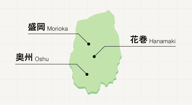
A northern Tohoku prefecture promising peace and quiet, Iwate is sparsely populated, replacing people with snow-capped mountains, history-rich sites, and fields of crops that are to thank for the region’s delicious local cuisine. Meander along the three-city Golden Route, where you’ll visit the grand Buddhist temples of Hiraizumi and the Tono folk villages before tasting the three famed noodle dishes of Morioka.
Iwate Photo Album
Best of Iwate
Search by Region
-
- Hokkaido / Tohoku
- Hokkaido
- Aomori
- Iwate
- Miyagi
- Akita
- Yamagata
- Fukushima
-
- Kanto
- Ibaraki
- Tochigi
- Gunma
- Saitama
- Chiba
- Tokyo
- Kanagawa
-
- Koshinetsu / Hokuriku
- Niigata
- Toyama
- Ishikawa
- Fukui
- Yamanashi
- Nagano
-
- Tokai
- Gifu
- Shizuoka
- Aichi
- Mie
-
- Kinki
- Shiga
- Kyoto
- Osaka
- Hyogo
- Nara
- Wakayama
-
- Chugoku
- Tottori
- Shimane
- Okayama
- Hiroshima
- Yamaguchi
-
- Shikoku
- Tokushima
- Kagawa
- Ehime
- Kochi
-
- Kyushu / Okinawa
- Fukuoka
- Saga
- Nagasaki
- Kumamoto
- Oita
- Miyazaki
- Kagoshima
- Okinawa


