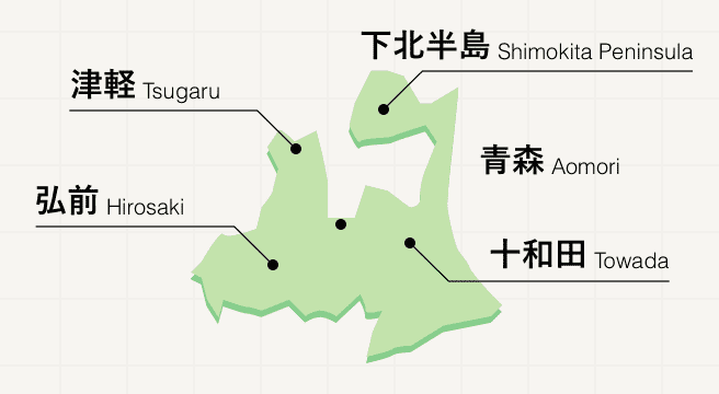
Nature Spots in Aomori Area
Area
-
-
Aomori


-
-
Aomori

Category
-
- Oirase Stream
-
![rating-image]() 4.51063 Reviews
4.51063 Reviews - Travel / Tourism
- Aomori Pref. Towadashi Okuse
- "Oirase Stream can be reached by a JR Bus service from JR Shin-Aomori Station; the journey takes around two hours. It is one of the most scenic places in the Towada-Hachimantai National Park; the river flows out from Lake Towada through the gorge for a distance of around 14 kilometers, from Nenokuchi to Yakeyama, with a road and a footpath all the way along, making it easy for visitors to experience the gorge's wonderful natural scenery. There are many ""must-see's"" in the area, including the Ashura Rapids, which are one of the Oirase Stream's best-known sights, and Choshi-otaki Waterfall, one of the most imposing waterfalls in the gorge. Visitors can see the new spring greenery in May-June, and view the autumn foliage in mid to late October; the winter scenery, when the ground is covered with snow, is also very beautiful."
-
![]()
Generally speaking, the Oirase Stream is hard to access by public transport during winter due to road closure, but the winter sight is awesome which is something I realy wanted to see. So I joined...

-
- Lake Towada
- Travel / Tourism
- Aomori Pref. Towadashi Okuse Towadakohanyasumiya
- A lake which straddles Towada City, Aomori Prefecture and Kosaka Town, Kazuno County, Akita Prefecture. 46 kilometers in diameter, this caldera lake was formed through volcanic activity. With a maximum depth of 327 meters, it is the third deepest lake in Japan. On its east side, the lake drains into the Oirase River and the area has been designated a Natural Monument as well as a Special Place of Scenic Beauty under the title “Lake Towada and Oirase Stream.” Here visitors can enjoy seasonal natural scenery, including fresh verdure in summer and fall foliage in autumn. Kokanee salmon are also raised in the lake and during fishing season many people come here to fish.

-
- Ashura no Nagare (Kujuku Islands)
-
![rating-image]() 4.543 Reviews
4.543 Reviews - Travel / Tourism
- Aomori Towada-shi Okuse
- "Oirase Stream is one of the most picturesque areas in Towada-Hachimantai National Park. The area around the stream is famous for the beauty of both its new spring verdure and fall foliage. Making its way between boulders and forest and consisting of waterfalls, rapids, and calm stream, the 14 kilometer long stream extends from Nenokuchi on the shore of Lake Towada to Mt. Yakeyama, and the area known as Ashura no Nagare is said to be the most dynamic and beautiful portion of the stream of all. The various rocks and boulders dotting this part of the stream, known as the ""Kujukushima Islands,"" are also beautiful."
-
![]()
奥入瀬渓流では必見のポイントの1つです。写真撮影にも最適です。豪雨の影響で濁りが残っているとのお話でしたが、それでもかなりキレイでした。

-
- Omazaki Cape
- Travel / Tourism
- Aomori Pref. Shimokitagunomamachi Oma Omataira
- Located on the northernmost tip of Honshu, Japan’s largest island, Omazaki Cape looks out over the Tsugaru Straits. There is a stone engraved with the words “This is the northernmost point of Honshu” and when the weather is clear one can look out and see Hokkaido’s Hakodate across the straits. Since Oma is famous for tuna, the giant statue of a tuna that represents fishing is a popular spot for commemorative photos.

-
- Aoike Pond
- Travel / Tourism
- Aomori Pref. Nishitsugarugunfukauramachi Matsukami Mountain National Forest
- One of the 12 lakes in the Shirakami-Sanchi area; ao means blue in Japanese, and as its name implies, the waters of this beautiful pond are a clear cobalt blue. Struck by rays of sunlight filtering through the surrounding trees, the sparkling blue surface of the pond is magical to behold. There is also a walking path, making it easy to visit the pond.

-
- Tappizaki Cape
- Travel / Tourism
- Aomori Pref. Higashitsugarugunsotogahamamachi Minmayatatsuhama
- Tappizaki Cape is located in the extreme north of the Tsugaru Peninsula—it is a cape which juts out into the Tsugaru Strait. “Tappizaki Lighthouse” located on this cape was also selected as one of the 50 Best Lighthouses in Japan. An esplanade is maintained in the environs of the cape, and when the climate is good, you can command a view of Tsugaru Strait and also of Matsumae Peninsula in Hokkaido. There are monuments such as the “literary monument of Osamu Dazai” which has a sentence from “Tsugaru” by Osamu Dazai carved on it, and there is also the song monument of “Tsugaru Kaikyo Fuyu-geshiki” (Waterscape of the Tsugaru Straits) sang by Sayuri Ishikawa.

-
- Shirakami-Sanchi
- Travel / Tourism
- Aomori Prefecture, Akita Prefecture
- Shirakami-Sanchi is the general name for an extensive mountain range that extends from the southwestern part of Aomori Prefecture to the northwestern part of Akita Prefecture, and the area was registered as a World Heritage Site in 1993. Natural beech forests are distributed throughout this area which protects a precious ecosystem inhabited by a variety of wild plants and animals and is said to be the largest in East Asia.

-
- Hakkoda
- Travel / Tourism
- Aomori, Aomori Prefecture Hakkoda
- This is the general name for a group of volcanoes located south of Aomori City, composed of six mountains including Kita Hakkoda and Kushigamine with Odake having the highest peak, divided by Minami Hakkoda. This is one of the top 100 mountains in Japan. There are beautiful beech forests and valleys, with several walking courses where one can see many types of grassland and alpine plants. The ropeway installed at Tamoyatsudake is used by many hikers and skiers. This is one of the world’s areas of heaviest snowfall, known for the 1902 “Hakkoda Mountains incident” in which 199 of the 210 members of the Aomori army 5th regiment were stranded and died in a blizzard.

-
- Hotokegaura
- Travel / Tourism
- Sai village in Shimokita-gun, Aomori Prefecture
- Hotokegaura is a series of impressive giant and oddly shaped rock formations extending about two kilometers along the coast. The crashing waves continually erode the rock face, and the resulting effects are mysterious and an amazing sight, especially given the contrast between the broad, blue sea and the gray rocks. It is believed that these rocks were created by undersea volcanic activity about 20 million years ago. While the rocks are visible from land, it is also possible to take an excursion boat to see them from the sea.

-
- Mutsu City Wakinozawa Wild Monkey Park
- Travel / Tourism
- Aomori Mutsu-shi
- This park keeps around 50 Japanese macaques, a monkey which was designated as a natural monument in 1970 since the place is at the northern limit of range for Japanese macaques. Besides tennis courts and hiking trails, Yamamura Square also offers an assortment of variously sized bungalows, from family-size ones to large ones for up to 15 people.

-
- Mt. Iwaki
- Travel / Tourism
- Hirosaki City, Aomori Prefecture
- This is a 1,625 meter high double volcano known as Aomori Prefecture’s highest. There is a toll road leading near to Mt. Iwaki’s eighth station, the Tsugaru Iwaki Skyline, as well as a lift to the Mt. Chokai crater, so it’s perfect for an easy climb and relaxing walk. The peak offers a view of the Hakkoda Mountain Range, Shichiri-Nagahama beach and, if the weather is good, all the way to Matsumaezaki in Hokkaido.

-
- Tsutanuma Pond
- Travel / Tourism
- Towada-shi, Aomori-ken
- One of the Tsuta Seven Lakes located in Towada-Hachimantai National Park. The Numameguri no Komichi Path Course connects all of the lakes except Akanuma and trail walkers can enjoy the seasonal natural beauty of the area. Visitors are particularly recommended to come during the fall foliage season. The sight of the leaves reflected off the surfaces of the lakes, dying their waters red to match the foliage, is truly spectacular.

-
- Lake Jusanko
- Travel / Tourism
- Aomori Pref. Goshogawarashi Jusan Tsukoudou
- Seven kilometers long north to south, five east to west, and 31.4 kilometers in circumference, this is one of the largest lakes in the prefecture. Jusanko means thirteen lake, and it is believed the lake got its name due to the Iwaki River, Yamada River, Miyanosawa River, and 10 other rivers which flow into it. Located on the west coast of the Tsugaru Peninsula, the lake's waters are brackish-a mixture of fresh and salt water-and, together with Lake Shinji and Lake Ogawara, this lake is known as one of the top areas in the country for producing basket clams. Rare wild birds such as Steller's sea eagles, a designated Natural Monument; and marsh grassbirds, known as the phantom bird, live or make stops here, and the lake is also renowned as a paradise for birdwatchers.

-
- Bense Marsh
-
![rating-image]() 2.01 Reviews
2.01 Reviews - Travel / Tourism
- Aomori Tsugaru-shi
- This marshland is in the Kizukuritateoka area of Tsugaru City. This approximately 23 hectars of marshland is located within the Tsugaru Quasi-National Park. Visitors can enjoy various seasonal perennials throughout the year, like the day lily that is first to bloom in June and the field iris which blooms later in the month.
-
![]()
2021年はコロナで訪れる人が少なくなるのか、コロナで予算が不足するのか整備を行わないようで湿原の木道も草に覆われていて歩くのも困難です。時期もニッコウキスゲの時期でなかったのも印象が悪くなったのかも知れません。 木道が見えない中を歩きましたが、木道が腐ってなく湿原に落ちなかったのだけは幸いでした。

-
- Anmon-no-taki Waterfalls
- Travel / Tourism
- Aomori Pref. Nakatsugarugunnishimeyamura Kawaratai Okawazoe
- Shirakami-Sanchi became Japan's first World Heritage Site in 1993 because it's home to a variety of rare plants and animals. Anmon-no-taki Waterfalls in the Shirakami Mountains consists of three cascades. The first waterfall at the top is 42 meters high, the second is 37 meters high, and the third is 26 meters high. A walking path and boardwalk connect the Anmon Rest Area to the first waterfall via the Anmon Valley Route, but since there's the danger of falling rocks in some spots, hikers need to report that they are using the trail. Advanced booking is recommended for hiring a guide to go with you.

-
- Juniko Lakes
- Travel / Tourism
- Aomori Pref. Nishitsugarugunfukauramachi Matsukami National forest
- "This is the name given for the 33 lakes and swamps on the undulating plateau of Fukaura Town. A landslide caused by an earthquake in 1704 is said to have created the lakes from part of a stream becoming filled. The small lakes are hidden by the forest when seen from Okuzure located in the middle of Mt. Kuzure, and the name ""Juniko"" (12 lakes) comes from the fact that only 12 large ones can be seen. Lake Aoike, with its distinctive pure blue water that looks as if ink was spilled, is often given as a lake representing them all. The colors that change according to the season and time is the main attraction. In addition, you can also enjoy strolls while observing animals and plants that inhabit the surrounding forest."

-
- Cape Natsudomarizaki
- Travel / Tourism
- Aomori Pref. Higashitsugarugunhiranaimachi Higashitazawa Yokomine 68-1
- This cape is in Higashitazawa, Hiranai Town, Higashitsugaru County. It is located at the tip of the Natsudomari Peninsula that extends into Mutsu Bay, between the Tsugaru Peninsula and the Shimokita Peninsula. A sandbar links it to Oshima Island at low tide, and there's a bridge that provides access at high tide to sites like the Mutsu Oshima Lighthouse. Mt. Tsubaki, the northernmost area of the country where Japanese camellias grow wild, is about two kilometers east of the peninsula. It has been designated a National Natural Monument

-
- Yagen Stream
- Travel / Tourism
- Aomori Pref. Mutsushi Ohatamachi Yagen
- This river is located in Ohata-machi, Mutsu City. The rich, largely untouched environment offers a great experience of Japan's seasons. Several kilometers of walking paths run through a woodland of cypress, beech, maple, and others between Yagen Onsen and Okuyagen Onsen.

-
- Nihon Canyon
- Travel / Tourism
- Aomori Nishitsugaru-gun Fukauramachi Matsukami Matsukamiyama Kokuyurin
- This is a scenic spot in the Matsukamiyama National Forest located in Fukaura Town, Nishitsugaru County. Named after the grand canyon, here, one can see the white volcanic tuff rock cliffs exposed from erosion. From here one can see the hiking courses surrounding the Juniko twelve lake area.

-
- Sabishiro Beach
- Travel / Tourism
- Aomori Misawa-shi Misawa Hamadori 902-3
- "This beach is famous for being the point of departure of ""Miss Veedol,"" the plane that made the first successful nonstop trans-Pacific flight. Aside from the commemorative plaque, there is also a display of a life-sized Miss Veedol model and across it is a viewing platform that lets you experience what it was like on that historic day. The long coast from north to south and the windbreak extending along it is beautiful. It has also been selected as one of the top 100 top 100 white sand beaches and green pine groves of Japan."


Aomori Areas
Centuries-old stories of samurai at Kakunodate and the remains of millennia-old archaeological sites including the likes of Isedotai invite history buffs to delve into Aomori’s fascinating history. As the most northern prefecture on the Japanese mainland, Aomori enjoys a cooler climate, which makes it a welcome escape from the southern cities for combining castles, art galleries, and summer festivals with the great outdoors.
Aomori Photo Album
Best of Aomori
Search by Region
-
- Hokkaido / Tohoku
- Hokkaido
- Aomori
- Iwate
- Miyagi
- Akita
- Yamagata
- Fukushima
-
- Kanto
- Ibaraki
- Tochigi
- Gunma
- Saitama
- Chiba
- Tokyo
- Kanagawa
-
- Koshinetsu / Hokuriku
- Niigata
- Toyama
- Ishikawa
- Fukui
- Yamanashi
- Nagano
-
- Tokai
- Gifu
- Shizuoka
- Aichi
- Mie
-
- Kinki
- Shiga
- Kyoto
- Osaka
- Hyogo
- Nara
- Wakayama
-
- Chugoku
- Tottori
- Shimane
- Okayama
- Hiroshima
- Yamaguchi
-
- Shikoku
- Tokushima
- Kagawa
- Ehime
- Kochi
-
- Kyushu / Okinawa
- Fukuoka
- Saga
- Nagasaki
- Kumamoto
- Oita
- Miyazaki
- Kagoshima
- Okinawa


